RING FACILITIES
The RING network is an open research infrastructure that provides valuable data and products to support geophysical studies as well as a wide range of scientific projects.
It manages continuous GNSS stations across Italy and archives GNSS data from thousands of stations along the Eurasia-Africa plate boundary, making the processed time series publicly available. We promote cutting-edge research and provide a unique platform for a multidisciplinary approach to Earth sciences.
- Network of continuous GNSS stations: The RING network is composed of continuously operating GNSS stations, primarily located on the Italian peninsula, and plays an active role in the European Plate Observing System (EPOS). The network monitors slow tectonic deformations and the abrupt movement caused by earthquakes while also contributing to the observation of hydrologic and atmopheric phenomena.
- Archiving facility of daily and high-rate data: The archiving facility archives and provides public access to all GNSS data from the RING network, including both high-rate (1-20 Hz) and low-rate (1/30 Hz) data. In addition to RING data, all available GNSS data from the Mediterranean area are archived and screened for metadata validation RING data and products can be accessed through web-based graphical user interfaces (such as the EPOS-GLASS node), command line clients, and web services.
- Processing of Real time data: Real-time streaming of 1 Hz station positions is available for near real-time earthquake monitoring and the extraction of relevant parameters, such as peak ground displacement (PGD), magnitude, and other source parameters.
- High Performance Computing facility for long-term time series: A dedicated HPC facility allows the parallel processing of GNSS data with different software and analysis strategies. This computing environment enables efficient re-analysis of long lasting time series through both double-difference (DD) and Precise Point Positioning (PPP) aproaches.
SITES AND MONUMENTS
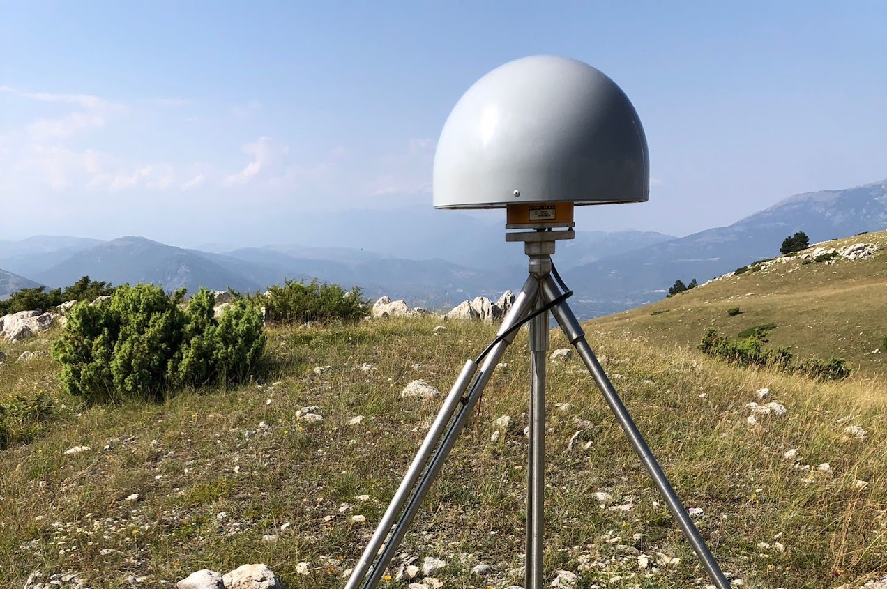
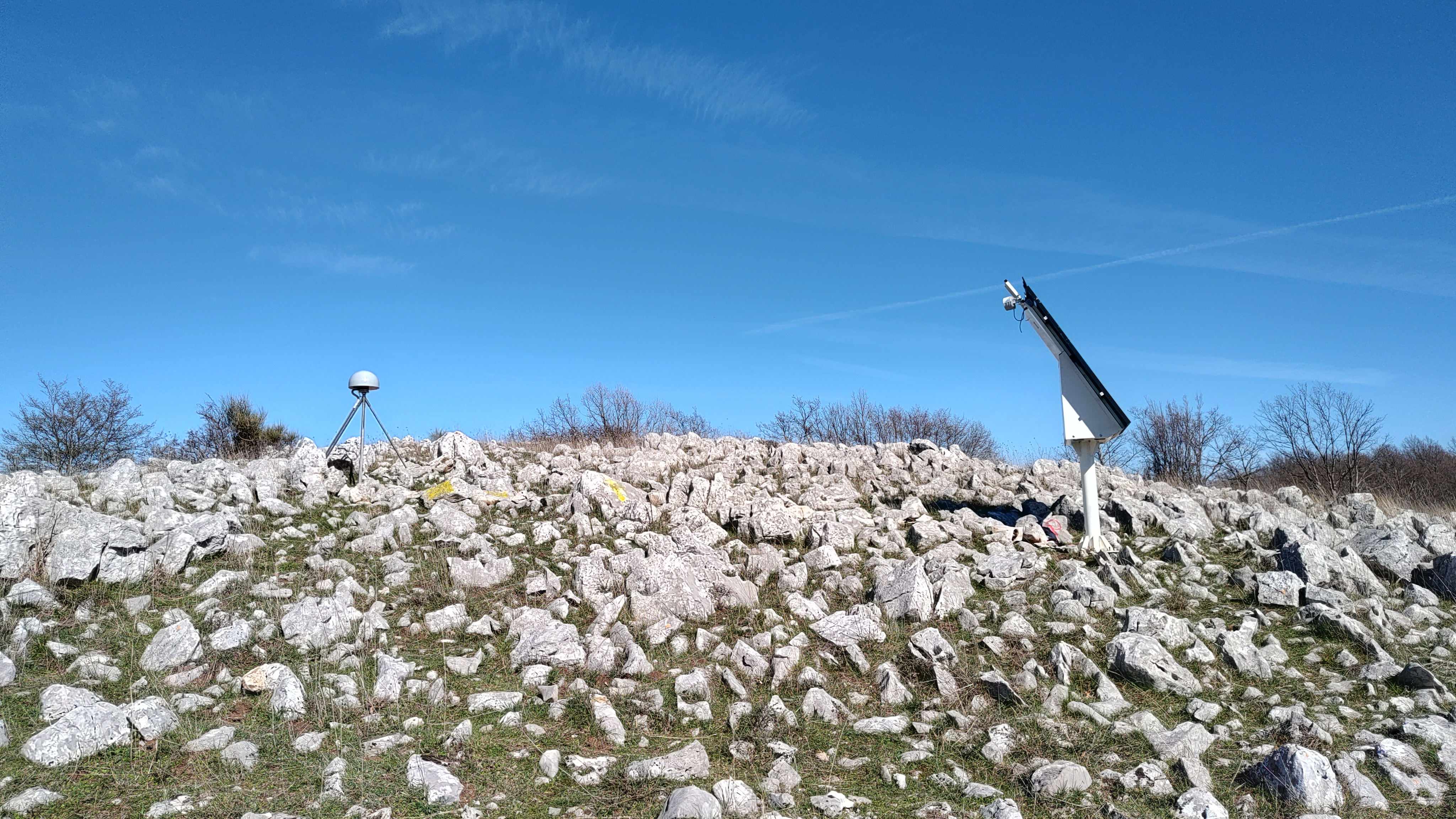
Most stations are mounted on shallow or deep-drilled, braced monuments in open fields and also host seismic instruments, either seismometers or accelerometers. The monument structure consists of stainless steel legs arranged in a tripod configuration, securely anchored to the ground using epoxy resins (see UNAVCO Tripod Monuments). A few stations are constructed on concrete pillar monuments, anchored into the ground with four lateral rods extending 1 meter deep for enhanced stability. All GNSS receivers and antennas are high-grade geodetic instruments, ensuring best performance in terms of stability and accuracy.


DATA FORMATS
UNDER CONSTRUCTION
ANALYSIS STRATEGIES
GAMIT Analysis setup
Analysis description
GIPSY Analysis setup
GPS data from GNSS stations were reduced using the Jet Propulsion Laboratory (JPL) GIPSY-OASIS II software (version 6.3) in a precise point positioning mode (Bertiger et al., 2010) applied to ionospheric-free carrier phase and pseudorange data and using JPL’s final fiducial-free GPS orbit products (JPL GNSS Products). A detailed description of the data analysis strategy and models is reported in this table.
(1) ocean tidal loading and companion tides (Scherneck, 1991) computed by the Ocean Tide Loading Provider (Scherneck1991) using the FES2004 ocean tidal model (Lyard et al., 2006) and applied it as a station motion model;
(2) estimation of wet zenith troposphere and two gradient parameters every 5 minutes as a random walk process (Bar-Sever et al., 1998) using troposphere mapping functions (Vienna Mapping Functions 1, VMF1, (Boehm et al., 2006) developed based on data from numerical weather models (e.g. from the European Centre for Medium-Range Weather Forecasts (ECMWF);
(3) antenna calibrations for ground receivers and satellite transmitters (Schmid et al., 2007);
(4) second order ionospheric correction (Kedar et al., 2003);
(5) estimation of station clocks as a white-noise process.
Ambiguity resolution was applied using the wide lane and phase bias (WLPB) method, which phase-connects individual stations to IGS stations in common view (Bertiger et al., 2010). Resolving ambiguities reduces significantly the scatter mostly in the east component of time series. Satellite orbits and clock parameters were provided by JPL who determine them in a global fiducial free analysis using a subset of the available IGS core stations as tracking sites. The fiducial-free daily GPS solutions are aligned to IGS14 (Rebischung et al., 2016) by applying a daily seven-parameter Helmert transformation (three rotations, three translations, and a scale component) using parameters obtained from JPL (x-files). In order to reduce the common mode signal we also align daily solutions in the IGS14 reference frame defined by Cartesian coordinates and velocities for 132 stations selected by specific quality criteria. This frame is aligned in origin and scale with IGS14 and it is implemented to have no-net rotation with respect to the stable interior of the Eurasian plate, realized by subtracting a rigid rotation estimated from a 32-station core subset. This reference frame realization method transforms the station time series into a plate-fixed frame and effectively applies a continental-scale spatial filter to the station coordinates, leading to a reduction of the common-mode errors (Wdowinski et al., 1997), and to an increase of the signal-to-noise ratio.
BERNESE Analysis setup
The Bernese Analysis Centre uses the Bernese software Version 5.2 (Dach et al., 2015), estimating daily coordinates of a network of stations together with the station-specific troposphere parameters.
Data: the RING network is analyzed together with other networks in the Mediterranean region, considering GPS, Galileo and Glonass observations. For computational efficiency the full network is divided into 19 sub-networks, each with about 60 or fewer stations. To allow the combination of the sub-networks into a full network daily solution, each sub-network contains a minimum of 16 tie stations.
Time series: daily coordinates of each sub-network are estimated by assigning an a-priori loose constraint of 10 m to all site coordinates. In this way, sub-network coordinates are expressed in a loosely constrained reference frame (i.e. site coordinates are systematically translated or rotated from day to day). To form the full network daily solutions, the sub-network solutions are combined into a global network solution using a classical least-squares approach where the coordinates are both observations and estimated parameters (Bianco et al., 2003). After the combination, in order to express the GNSS time series in a unique reference frame, the daily solutions are first projected imposing tight internal constraints (at millimeter level), and then the coordinates are transformed into the ITRF2014 frame by a 3-parameter Helmert transformation (translations only).
TIME SERIES
UNDER CONSTRUCTION
THEMATIC MAPS
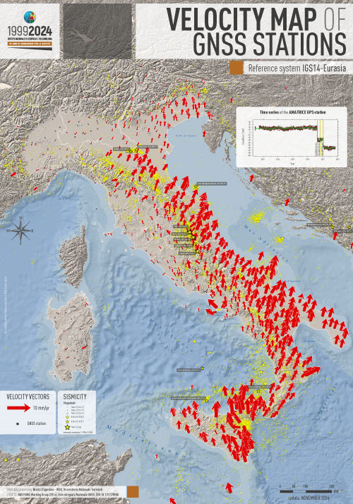
Map shows the horizontal velocity vectors of the Italian GNSS stations and the surrounding areas in a reference system in which the velocity of the stations located on the stable part of the Eurasian plate has been minimized.
Diagram (top right) shows the trend of the vertical displacement of the Amatrice GNSS station. The (negative) displacements suffered by the station in relation to the repeated seismic events of the Amatrice-Norcia-Campotosto seismic sequence of 2016-2017 are evident.